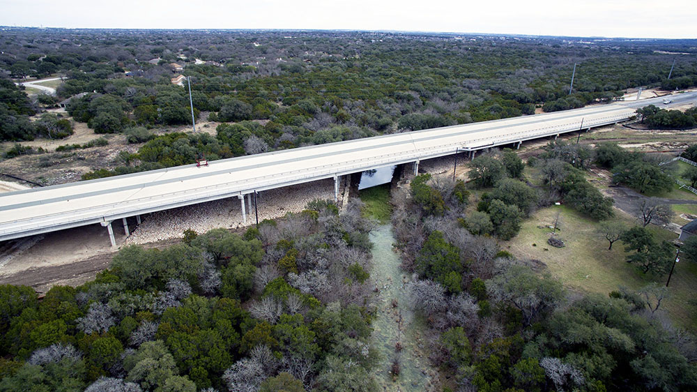
The opening of a new 5.8km stretch of State Highway 45SW marks a major change for the US city of Austin, Texas. This new tolled route features two lanes in either direction and will deliver a significant improvement in journey times for drivers, cutting peak time congestion in the city’s south-west area. The project has had a long and torturous history, with numerous starts and stops over a number of decades but it is now finally open for use.
The new road link is also of note as it has been designed and constructed to meet tough environmental constraints, as well as establishing a new quality level for sustainability. Environmental factors were amongst the challenges that had held back the start of the construction work for so long. And SH 45SW is also the latest in a series of road projects around the city, further helping to reduce journey times and providing much-needed capacity for the future.
Costing US$109 million for the design project oversight, legal and construction work, the new highway stretch will make a substantial contribution in transportation for Austin, a city notorious for its traffic congestion at peak periods. Unlike its fellow Texan cities of San Antonio and Houston for example, Austin does not as yet have a complete bypass around it.
The SH 45SW road link has had a long history, having taken several decades to be built. The stretch was first proposed in the 1980s as part of a loop around Austin that was designated the SH 45 Outer Parkway by the Texas Transportation Commission in 1985. The Texas Department of Transport (TxDOT) authorised a feasibility study for the SH 45 Outer Parkway route in 1987, with SH 45SW forming Segment 3. But work on the project then stalled, partly due to a shortage of available funds and partly because of the potential complexity of the project, including the environmental factors.
However, the need for this small but crucial section of highway, SH 45SW, had become ever more acute and in 1997, the land required for the link was purchased. In 1999, the Texas Transportation Commission then gave budget approval for the SH 45SW to be built. The project for SH 45SW stalled again and there were more delays due to financing issues and environmental questions. But work had started on other sections of SH 45, with the northern part of the loop opening first.
The SH 45 Southeast route was itself the subject of controversy and faced a number of legal challenges before a new environmental study was carried out and the alignment approved, with construction work finally getting under way in mid-2007. Construction of the SH 45 Southeast completed the SH 45 eastern bypass loop around Austin.
Finally in 2007, the Capital Area Metropolitan Planning Organization (CAMPO) approved SH 45SW as part of the Long Range Transportation Plan. But the plans for the highway stretch then stalled again, being revived once more in 2014.
The need for the section had become ever more acute as a steady increase of traffic in Austin had slowed journey times further for the city’s long-suffering drivers. The reason was apparent as the population in the area had climbed by 241% in the period from 1990 to 2010.
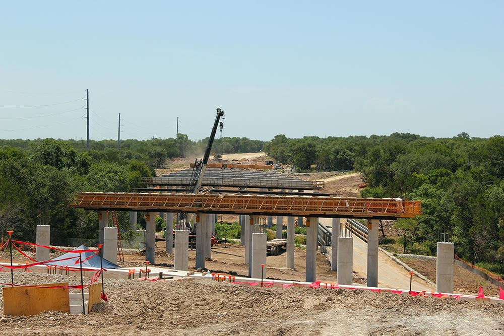
As the city’s population grew, so did the congestion problem and the need for new road links. With budgets tight, the Central Texas Regional Mobile Authority used a novel approach to secure the necessary funding. Travis County provided $15 million while Hays County provided $5 million, which was in addition to a loan worth $60 million from the Texas Department of Transportation. A further $29 million grant was provided by CAMPO. In July 2016, McCarthy Building Companies was selected to build the project after submitting a construction bid of $75 million.

With the area’s population expected to continue to grow by a further 40% between 2010 and 2035, the need for additional road capacity is clear. Had nothing been done to lower traffic congestion in the area, journey times by 2035 would have increased by an estimated 89-97% for the morning peak period and 42-90% for the evening rush hour.
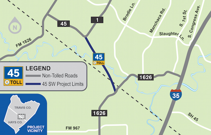
The SH 45SW link has been built as a four-lane toll road that connects Austin’s State Loop 1 (MoPac) route with the FM 1626 road. There are two 3.66m highway lanes in each direction with a 3m outside shoulder and a 1.2m or 1.5m inside shoulder, while median widths vary.
This new link gives Austin’s drivers an alternative to some of the gridlocked streets such as Manchaca Road, Slaughter Lane and Brodie Lane. And those drivers using the SH 45SW Toll Road on their morning commute to Central Austin can expect to save 9-17 minutes compared with driving local routes. The presence of the new toll road will also help to decongest the area’s local roads, with those drivers still using these routes saving 6-7 minutes compared with current travel times.
There are several key aspects of this new four-lane road for relieving congestion in Austin. One key feature is the widening of the existing eastbound and westbound SH 45 and northbound and southbound MoPac bridges over Danz Creek. Other important features are the four direct connector bridges at the MoPac Interchange, the new entrances and exits at FM 1626, Bliss Spillar Road, MoPac, and existing SH 45 and the overpass at Bliss Spillar Road as well as the bridge spanning Bear Creek.
Meanwhile, the project also includes a 3m-wide shared use path that will be compliant with the requirements of the Americans with Disabilities Act. This is separated from the roadway for the entire length of the expressway, except over the Bear Creek Bridge. The path will also be part of the planned Violet Crown Trail, with a trailhead under the bridge structure at the intersection of SH 45SW and MoPac.
Green highway
The builders laid a permeable friction course (PFC) for a majority of the road surface, as this better suited the environmental requirements. The PFC was used as an overlay on top of a conventional roadway surface. This was utilised for benefits such as its ability to filter suspended solids and pollutants from stormwater. In addition, PFC helps with sound dampening as well as reducing water spray in heavy rain, improving visibility and safety.
Environmental factors figured highly in the project, with one priority being to protect water quality. The route is in close proximity to a number of natural water springs, notably Edwards Aquifer and Barton Springs. To protect the extensive karst features in the area, around 90% of the project was built above ground level on fill dirt and did not require excavation.
To ensure the aquifers would not be affected adversely, the Mobility Authority ruled that the section of SH 45SW would minimise environmental impact. The requirement was for a highway runoff total suspended solids (TSS) removal rate of at least 90%. The designers and builders managed to beat this minimum target by some measure, with an actual removal rate of 98% around the aquifers and 92% along the rest of the project.
A number of methods were used to avoid, or at least to minimise, the levels of pollutants from the roadway entering the runoff. These included a combination of water quality ponds and vegetated controls such as grassy swales. Vegetated filter strips were utilised in areas without kerbs or other infrastructure for stormwater conveyance. In addition, multiple hazardous materials traps were located at all creeks, waterways, and culverted drainage ways, and each adequately sized to contain a 38,000litre spill.
Strict environmental measures were set out for the construction phase and these will continue during the operation of SH 45SW also. These are extensive and one of the key issues is eliminating the risk of any pollution entering the groundwater. For example, there will be no herbicide use within the right-of-way while there will be periodic inspections of hazardous materials traps, as required by the rules covering the Edwards Aquifer.
There is a recognition that vacuum trucks may be needed in the case of incidents resulting in soil contamination or a liquid spill. For these, a vacuum truck can be used to pump unwanted wet or dry materials from a construction site. The need for key environmental measures is determined in cooperation with an independent environmental compliance manager, who monitored activities and assisted the contractor in maintaining environmental compliance.
Any fuel or hazardous material storage for the construction equipment had to be within a containment area to prevent any accidental discharge to groundwater. Fuelling also had to be performed at least 60m away from the nearest sensitive karst feature and water crossing. Phased construction practices were utilised, where feasible, to limit the area and duration of disturbance.
Smart technology
Because it is a tolled section, the expressway has benefited from employing the latest traffic control technology. Modern tolling systems are in use along the route, so drivers do not need to stop at tolling booths to pay. Drivers not having an electronic tag in their car will be billed to their registered address. A key safety feature of the SH 45SW stretch is its new system intended to tackle the issue of wrong-way driving.
This is the first time such technology has been used in Texas and it features a number of sensors installed along the highway. These sensors can detect when a vehicle is heading in the wrong direction along the route. That information is then transmitted wirelessly to other vehicles equipped with the latest connected vehicle technology, alerting the drivers to the hazard. Drivers not using a connected vehicle are alerted by flashing warning lights mounted at the side of the route.
Looking ahead
Eventually, a new stretch will be built to connect the SH 45SW section with SH 45 Southeast, completed in May 2009. The 12km SH 45 Southeast expressway is tolled and connects SH 130 and US 183 to I-35.
The planned link between SH 45SW and SH45 Southeast will be called SH 45 South and it will run between FM 1626 and I-35, having already been included in the CAMPO 2040 Plan for study. But it is worth noting that this section was a focus of controversy for both the SH 45SW and SH45 Southeast projects. There was concern that once these sections had been built, there would be pressure to connect the two in an area of environmental sensitivity.
Lastly, the plans to develop the western stretches of the SH 45 route so that it could form a complete loop are at the very early stages. A proposed alignment has been suggested but this project has not yet progressed any further.
Financing
The highway section had to be built as a tolled route as federal and state fuel taxes can no longer meet the transportation needs of Central Texas. Fuel taxes have not been adjusted for inflation since 1993, while highway construction and maintenance costs have increased enormously. In addition, gains in vehicle fuel efficiency has further reduced revenue from fuel taxation.
Between 2015 and 2024 CAMPO estimates that the area around Austin will benefit from $2.5 billion in highway funding from federal and state sources. However, the cost of upgrading IH-35 through Hays, Travis and Williamson Counties alone comes with an estimated pricetag of $4.5 billion.
The Texas Transportation Commission has set out extensive plans for developing transport in the state. It approved a 10-year transportation plan from TxDOT for over $77 billion that will be used to boost safety, cut congestion and improve connectivity. The plan will also ensure that the state’s roads are properly maintained.
This plan is titled the 2020 Unified Transportation Program (UTP). It includes provision for $4 billion to be spent on safety upgrades, with an extra $600 million for measures intended to cut crashes and road fatalities. The planned safety upgrades include widening existing roads and upgrading barriers installed in median areas or on bridges. Guardrail will be upgraded, while safety improvements will be made at intersections, with new traffic signals and signage. There will also be better provision made for vulnerable road users such as pedestrians and cyclists.


")