The Mitla Tehuantepec II Highway represents an important infrastructure project for the development of Mexico’s Oaxaca State. Construction progress has been steady for the highway project in Mexico, despite a number of challenges. And according to the recent technical report provided by the country’s Ministry of Transportation (SICT), the highway is currently 70% complete and is scheduled to be completed by the end of 2023.
This key development of transport infrastructure is of vital importance to promote the economic and tourist growth of the Oaxaca region, located in the southern part of the country. Construction of the route has been undertaken with the aim of improving road safety, reducing transportation operating costs and travel times in the city. Driving from Oaxaca to the Isthmus of Tehuantepec has previously taken six hours, but the completion of the new highway will reduce the journey time to two hours. Safety will also be improved for drivers as the existing Route 190 has many tight turns.
This highway will provide a major boost for more than 80,000 inhabitants of the various communities in Oaxaca State that until now have not had the benefit of a paved highway.
The new highway runs between the municipality of San Pablo Villa de Mitla and the municipality of Santa María Mixtequilla. San Pablo Villa de Mitla is on the outskirts of Oaxaca, the capital of Oaxaca State, and located to the east of the city.
Meanwhile, Santa María Mixtequilla lies close to the Laguna Superior and the coastline. Building this new route will provide a new transport connection and benefit the communities of San Lorenzo Albarradas, Santa María Albarradas, San Pedro and San Pablo along the route. Also benefiting from the highway are Ayutla, Santo Domingo Tepuxtepec, San Pedro Quiatoni, Santo Domingo Narro, San Juan Juquila Mixes, Santiago Quiavicuzas, San Juan Lachixila, Santiago Lachiguiri and Santa María Jalapa del Marqués.
This important road infrastructure project will deliver better transport infrastructure for the Tehuantepec Isthmus Region, as well as with the neighbouring states of Chiapas and Veracruz, and will provide better access to the Mixe area. At present, the area has poor road connections, limiting economic development and also access to health or education facilities for the population.
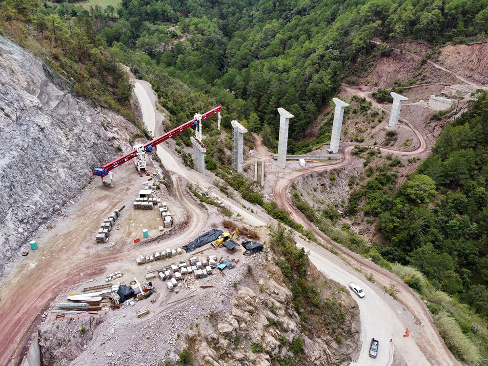
During the construction of the three sections that make up this highway, several construction problems have provided challenges to the builders. These have been due to the conditions related to the stability of the geological and topographical area in this mountainous region. There have been constant risks from large falling rocks as well as from landslides.
The alignment of the highway is actually located in a geologically complex region. This characteristic is attributed to the diversity of rock types found on the surface, as well as to the geological and structural characteristics of the region implicitly linked to its tectonic evolution. This last manifested itself with lithological changes produced by the emplacement of intrusive rocks and the segmentation of blocks of land with displacements generated by the dynamics of the lateral faults. Together, these play an important role in the formation of zones with a high degree of instability.
The Mitla-Tehuantepec II Highway is around 169km long and consists of 28 crossing structures, 13 viaducts, 20 junctions, 54 bridges, and 10 tunnels. Having so many civil structures has added considerably both to the cost and complexity of the works. Building bridges or tunnels where the formations are heavily faulted has meant that more support has been needed to ensure that the civil structures will be able to cope with the conditions. Many of the bridges have deep piling while thick concrete sections are used to support the tunnel stretches.
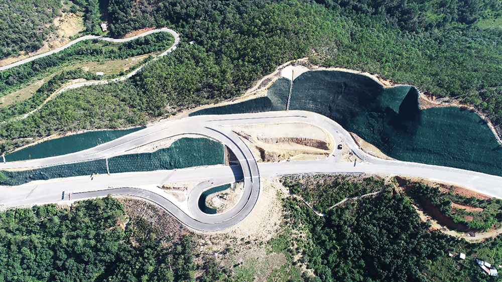
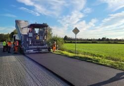
The road is being designed with a crown width of 12m and a width of 7m and has been designed for vehicle speeds of between 90 and 110km/h. A conventional asphalt construction method comprising wearing course, binder course and base course has been installed on top of the prepared base. The asphalt grades of these three layers have been selected to cope with the conditions.
So far, around 93.5km of the route is already in operation with a further 75.5km remaining under construction.
The new highway is divided into three main sections to facilitate the construction process. Section 1 is 26km in length and connects the city of Mitla with Santa María Albarradas. Section 2 runs from Santa María Albarradas to Santiago Lachiguiri, a distance of 94km. The third section connects Santiago Lachiguiri with the Tehuantepec II junction, a distance of 49km.
Section 2 includes the construction of three tunnels that have a total length of 460m with a section 12m wide and 9m high and a gauge of 5.5m.
Construction work has been completed for Sections 1 and Section 3 as these stretches have been less challenging. Section 2 is the most complex due to the challenging geological and topographical conditions, and work is ongoing as a result. For this reason, the Ministry of Transportation and Communications (SICT) expanded the geotechnical information with the important exploration works. The team carried out 14 survey bores and took samples to help develop the final design of the tunnel sections. In all, 211 open pit wells were also drilled to determine the thickness of the soils, and 365 refraction seismic profiles to depths of 60m and 120m were carried out to measure the thickness of the soils so as to be able to determine risk factors during excavation work.
According to the project approved by SICT, the superficial foundations of the bridges and viaducts were made using continuous footings when the resistance of the ground was very low. Meanwhile, deep foundations were utilised when it was necessary to look for more resistant soils. A high grade concrete was used for the foundation works.
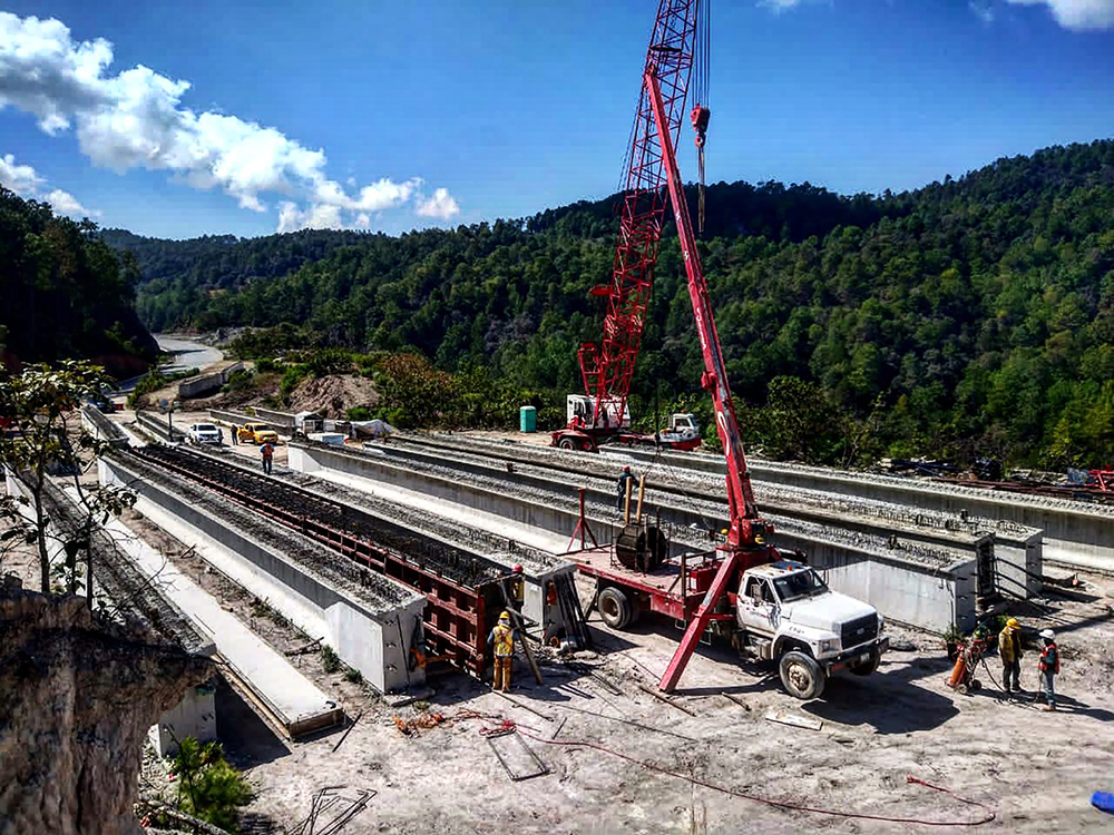
For the construction of the piers, Bauer and Soilmec piling machines were used. The piles used a high grade of concrete and the reinforcing steel was placed using a Link Belt LS 108 crane. The ‘Nebraska’ type precast beams were 30m in length and the engineering team used mobile launchers that were 50m long with capacities of up to 150tonnes.
The construction method used in this project has consisted of placing rails that allow the assembly of the precast beams together with the casting of the slabs, exchanging the rails and the launching equipment after a certain number of spans.
This equipment is said to allow greater efficiency as the contracting team is able to work in different areas of the structure at the same time. This eliminates the need to wait for the assembly to be finished to start other tasks. By using the rails and the feeder truck, which is responsible for taking the girder to the launching equipment, construction times are also reduced significantly.

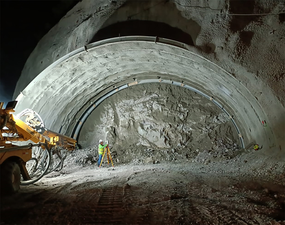
Conventional drilling and blasting techniques have been used to drive the three tunnels planned for section 2 in the municipality of Santiago Lachiguiri. This drilling and blasting method has utilised Epiroc drill jumbos, a Putzmeister PM 500 shotcreter, an excavator fitted with a hydraulic hammer, and a wheeled loader.
In general, and from a technological point of view, although the andesite rock on the surface of the tunnel interior was found to have a medium-high degree of fracturing (due to the regional faults of the Pacific coast of Oaxaca), in the depths of the tunnel the conditions were of better quality and resistance.
The tunnel section measures 14.8m wide by 9.44m high while the total length is 173m.
The supporting structure was made with fibre-filled shotcrete with a resistance coefficient of f'c=300 kg/cm2, IR 254 x 44.8 kg/m metal frames and 6m-long corrugated rod injected anchors. While the final coating is made of concrete, it was f'c=300 kg/cm2 with a thickness of 45cm. The false tunnel, with a length of 188m, was also lined with concrete f'c=300 kg/cm2 reinforced with a thickness of 60cm.
The last part of the work has concluded and was supervised by the president of Mexico Manuel Lopez Obrados on January 14, has been Subsection 5, is considered one of the most complicated from a technical point of view. Originating at the Ayutla junction and the Tepuxtepec junction, this important set of infrastructures is 8.5km long, made up of five viaducts that total a total of 786m. Subsection 5 connects directly through three areas (Ayutla, Loma Larga and Tepuxtepec) where around 10,000 inhabitants live.
SPECIFICATION
Total road length: 169km
Total road width
including shoulders: 12m
Road width: 7m
Progress (January 2023): 70%
Section 2
Length: 94km
Bridges and viaducts length: 6.5km
Length of the three tunnels: 0.46km
Source: SICT
Rural roads
Delivering this new highway will provide an important lifeline for this area of Mexico’s Oaxaca State. With the Sierra Madre del Sur, the Sierra Madre de Oaxaca and the Sierra Atravesada mountain ranges meeting in Oaxaca State, the terrain is very rugged in places and altitudes reach up to 3,759m. Lying in-between the mountainous area, the state has many narrow valleys, canyons and ravines that make transport challenging.
The new highway route will provide an important transport link that will provide better access both to the state capital, also called Oaxaca, as well as to the major port at Salina Cruz. Previously, the towns along the alignment of the highway have only had unmade roads as access, which has made transport difficult in periods of poor weather. Even in good weather, the rugged terrain has made journeys on the twisting unmade roads slow. The new highway will speed transport and deliver a major economic boost to the area. It will also allow access for tourism as the highly rugged location is known to be one of the most biologically diverse states in Mexico. Oaxaca State also has amongst the most historic and archaeological sites in Mexico, another major draw for tourism that will benefit from the new road connection.


")